I live in south Florida ........and the only thing i need to worry about is hurricanes ......you get lots of notice ....so if you fuck around...... with your fingers up your arse ....you deserve to get fucked .....simple .....unlike an earthquake ........ it just fucking hits you ........no warning just boom!!!!!.......hurricanes are days away ......so you fill your tank........ and go to the hard rock hotel....... and park in there for a few days/week/month..... .....simple ....gambling ....whores ........ food ....alchohol .......sports .....yeah baby !!!!!!!!!!!!i do not drink but alcohol is there ....lots of it ....i have been to hard rock in many hurricanes .....greatest place ever .......this is why i love south Florida..... and the work afterwards is lots .......so it is a win win situation ......
More than 50 million under severe weather threat from Texas to Virginia, with possible tornadoes and damaging winds
A wide-ranging storm system is moving across the United States, bringing the threat of severe storms, flooding and snow across central and eastern parts of the country.
The potential for damaging weather is ramping up Monday, with more than 50 million people at risk for severe storms from Texas to Virginia.
Some of the same atmospheric energy that fueled thunderstorms and soaking rain in California over the weekend will help charge up the early week severe threat.
Drenching rainfall caused a cliffside “slip out” that sent part of Highway 1 along California’s Big Sur coast crumbling into the ocean Saturday afternoon, according to officials. Drivers must be escorted through the area for the next several days.
Now the focus for damaging weather turns to the eastern two-thirds of the country. Here’s how the threats will play out over the next few days.
Monday: Widespread risk of damaging wind gusts and tornadoes
Severe thunderstorms are possible in a nearly 1,500-mile-long area of the central and eastern US on Monday, with the greatest risk stretching from the Plains to the Midwest.
A Level 3 of 5 risk for severe thunderstorms is in place from northeastern Texas to far western Indiana, according to the Storm Prediction Center. Dallas, Oklahoma City and St. Louis are within this risk area.
Thunderstorms in this region could deliver damaging wind gusts and hail ranging in size from quarters to baseballs. Tornadoes are also possible, and a few could end up reaching EF2 or greater strength.
The greatest chance for strong tornadoes centers on parts of northeastern Oklahoma, southeastern Kansas and Missouri, mainly during the late afternoon and evening hours.
Damaging thunderstorms will reach their peak in the late afternoon and evening in the Plains, but this won’t be the case for areas farther east.
A Level 2 of 5 risk for severe thunderstorms includes portions of the Midwest and Ohio Valley Monday. These storms will likely peak during the late evening and overnight hours and will be capable of damaging winds, hail and a few tornadoes.
Research shows nighttime tornadoes are more than twice as deadly as daytime tornadoes. Tornadoes are difficult to spot in the dark and are more deadly because many people are sleeping.
Thunderstorms will rumble farther east into parts of the mid-Atlantic overnight, but the threat for severe impacts will become more isolated in nature.
Storms will also unload drenching rainfall and raise flooding risks.
Flood watches are in effect for over 8 million people from eastern Indiana to western Maryland Monday and Tuesday. Rainfall of 1 to 4 inches is possible, with isolated totals potentially reaching 5 inches.
Tuesday: Severe storm system shifts east
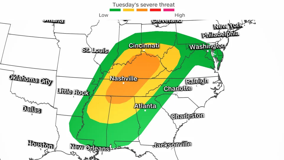
The severe thunderstorm threat will march east on Tuesday and include areas from the Gulf Coast through the Ohio Valley.
A Level 3 of 5 risk for severe thunderstorms is in place Tuesday from northern Alabama to southern Ohio. Nashville and Louisville, Kentucky, are within this area of greatest risk.
Surrounding states are under a Level 2 of 5 risk Tuesday. Both risk areas will face storms able to produce damaging wind gusts, hail and a few tornadoes.
Cold air pushing into the northern edge of the storm will change rain over to snow and a wintry mix later Tuesday in parts of the Midwest and Great Lakes. Rain and snow showers will continue in parts of both regions through Thursday.
Cities including Chicago could even see a few flakes, but little accumulation of snowfall is expected. The highest snowfall totals are expected across the parts of northern Michigan and Wisconsin.
Winter-like weather will shift into the interior Northeast on Wednesday. Higher elevations of the interior Northeast including the Green, White and Adirondack Mountains could pick up close to a foot of snow through Thursday.
The major cities across the Northeast, including New York City, Boston and Philadelphia, are currently forecast to see rain.
CN


No comments:
Post a Comment