I have said it now and will say it again ....this is why i live in south Florida ......always summer ......
15 million people in US face severe weather threat this week
A storm system that will move across the country this week brings with it the threat of severe weather for about 15 million people who live in the central U.S.
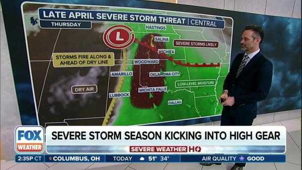
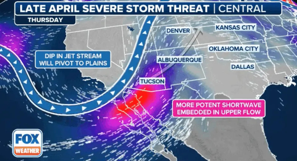
The FOX Forecast Center expects the first round of storms to develop on Thursday across the Plains, with Friday’s threat situated further north and east, over the eastern Plains and Midwest.
Similar to previous events, the threats are expected to begin as hail and damaging winds but will likely transition into a tornado threat as moisture and additional ingredients become available.
On Thursday, communities across three states are in an increased risk zone for severe weather.
In the heightened risk zone includes Wichita, Kansas; Wichita Falls, Texas; and Oklahoma City.
On Friday, a much wider area of the heartland is expected to be at risk for thunderstorms.
NEW SUMMER WEATHER OUTLOOK LOOKS TOASTY ACROSS MUCH OF US AS JUNE LOOMS LESS THAN 50 DAYS AWAY
The final day of the workweek is expected to bring the threat of showers and thunderstorms to more than half a dozen states.
"We are going to start to see that warm front start to push up into the upper Midwest," FOX Weather Meteorologist Jane Minar said.
The Storm Prediction Center has highlighted parts of Iowa, Illinois, Missouri, Nebraska, Kansas, Oklahoma and Arkansas as at increased risk.
"This is going to be a zone again where we recharge and see the threat for more severe storms. And at this go around, we could see the possibility of a few tornadoes," Minar said.
The risk zone includes communities such as Des Moines, Iowa, Kansas City, Missouri, and Tulsa, Oklahoma.
On Friday, atmospheric conditions are more suitable for severe weather, so hail, damaging winds and tornadoes will likely be in the increased risk zone.
Forecasters consider it likely that the SPC will issue either Severe Thunderstorm or Tornado watches, alerting residents to the immediate risk during the upcoming event.
A watch means severe weather is possible, and an alert is usually issued for a large region.
A warning means severe weather has been spotted or has been detected by radar, and you should take immediate safety precautions ahead of the approaching storm.
April's tornadic activity has been above average with 164 reports this month, nearly 20 reports above average.
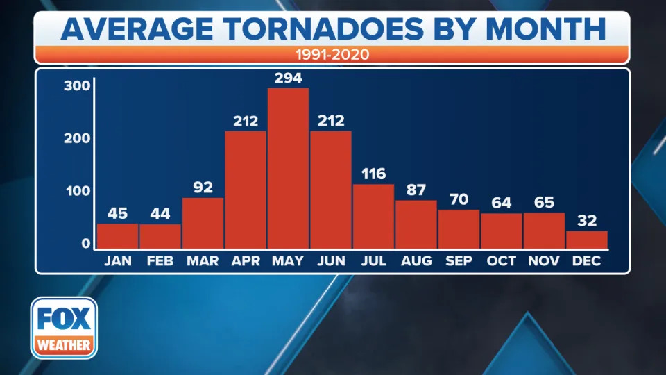
May is typically the most active month for tornadoes, with an average of 275–300 formations, according to the latest historical data from the SPC.
In 2024, the center has received 341 reports of tornadoes, which is more than 10% off from an average year.
"This past week really solidified us with above-average activity," Minar said. "And when you take a look at the month of April, where you typically see tornadic threats, it's more back off through the Plains. So you look into, say, Texas, portions of Oklahoma, even into parts of the Southeast, the Mississippi River region, but we've been seeing much more activity, you know, up across the Ohio Valley. Ohio leads the country with the number of tornadoes."
This week's weather will shift the tornado threat back into Texas and Oklahoma.
Severe weather outbreaks are more common during La Niña events than in El Niño or neutral episodes.
Several climatological organizations consider the Pacific Ocean to be in a neutral status of the El Niño-Southern Oscillation, or what is commonly referred to as the ENSO.
Original article source: 15 million people in US face severe weather threat this week


No comments:
Post a Comment